About
Our mission is to make cycling in Toronto as safe, accessible, and FUN as possible. Explore our collection of cycling routes and find the perfect one for your next adventure.
How to Use Cycle TO Fun
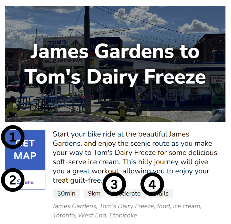
Find a ride by scrolling our home page, using the search bar, or clicking "Random Ride". Each ride has a "Get Map" button that links to a Google Map.

- Click "GET MAP" to get the Google Map directions for the ride.
- Click "Share" to send a link with ride information to a friend.
- There are 3 different ride difficulty ratings: easy, moderate, or difficult. This indicates the physical fitness level required for the ride. Check the distance and elevation change on the ride's Google Map for more details.
- There are 4 different ride infrastructure types: trails, cycle tracks, bike lanes, or side streets. Rides may feature multiple types of infrastructure. Only the most prevelant infrastructure type is listed. Check the ride's Google Map for full details.
How to Use Google Maps

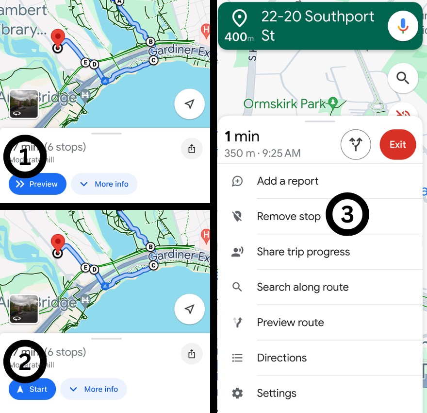
- Click "Preview" to view the cycling route in Google Maps. It's always a good idea to preview your route before you begin your ride.
- Once you arrive at the location of the ride's starting point, you will notice that the "Preview" button has changed to a "Start" button. Select the "Start" button to open the route in Google Map's navigation.
- Each ride map includes several checkpoints to ensure that Google Maps doesn't auto-redirect you away from the original route. If you accidently pass a checkpoint, and find Google Maps is telling you to go backwards, just delete that checkpoint by selecting "Remove stop" from the menu.
Advice for Cycling in Toronto
In addition to the technical information provided above, we offer the following general advice for utilizing our cycling routes:
- Always preview your ride's map before leaving your home. Ensure you are familiar with the streets and turns you will encounter during your ride.
- When making a left, use a two-stage turn. This means to make a left turn by crossing at an intersection, alongside pedestrians. All of the cycling routes on Cycle TO FUN are designed to accommodate two-stage left turns at major intersections.
- When following one of our cycling routes, never do anything that makes you feel unsafe. If traffic feels too intense or a hill is too steep, do not hesitate to walk your bike on the sidewalk for part of the route.
FAQ
As a rule of thumb, you can think of a "moderate" ride as being strenuous for someone who cycles casually and a "difficult" ride as being strenuous for someone who cycles regularly.
Your best bet is to view the ride's Google Map and make a judgement based on the ride's distance and elevation change.
Cycle tracks are bike lanes that are separated from vehicle traffic by parked cars, planters or some other physical object. Bike lanes are painted on the road, with no barrier between cylcists and vehicle traffic. Trails are completely separated from vehicle traffic.
More information can be found at www.toronto.ca.
If you would like to suggest the cycling route, please email your idea to [email protected].
Cycle TO Fun was made with Cloudflare D1, Remix, and DiasyUI.
